The Quantock School Campus
Finding your way there
While many of us may be forced to have a look at our atlases to find the way to the A39 Brigdwater-Minehead road, no-one who was a pupil at Quantock School is ever likely to forget the route into the school from the crossroads at March Mills to the in those days forbidding main entrance gate. If you have RealPlayer installed on your computer, you can view a small video of the drive through the gates (0.6MB, 42sec). It was one of those many things associated with the school that has been indelibly stamped in the heart and mind of every Quantockian.
Nevertheless, I have put some directions here, if only to remind people of the paths we trod in days gone by. One cannot ever forget the walks from the School to the sports fields in Aley, the cricket ground at Marsh Mills, or the long Saturday afternoon trek into the metropolis that is Nether Stowey. For added nostalgic effect, the directions themselves are taken, verbatim, from the 1981 edition of the School Prospectus.
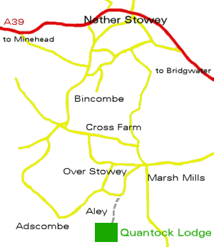
From Bridgwater: Take the A39 road in the Minehead direction through Cannington. About six miles from Bridgwater, after Cannington, and before reaching Nether Stowey, fork left at the signpost to Over Stowey. At the second intersection the hamlet of ALEY is signposted. The County Council have now attached QUANTOCK SCHOOL 'pointers'. The school is beyond the hamlet; the road leads nowhere else!
From Taunton: Take the road to Kingston St. Mary (Station Road, becoming St. Andrew's Road). This passes the railway station (under both railway bridges), with the old Gaeity Cinema on the left. Travel straight on. Do not turn left for Minehead and Bampton. After travelling for about eight miles the road Hawkridge Reservoir, where a great deal of junior sailing is carried on. Beyond this road passes the home of the Quantock weavers (on the right) and then the School Lodge (on the left). Turn left at the next crossroads - by Marsh Mills House - and drive to Aley (see above)
Below you will see a small schematic map of the route to the school from the A39, and all of the familiar landmark villages.